MISSOURI RIVER INTERIOR DRAINAGE STUDY

[Bottom of Page] [Figures]
This report is the culmination of an interior drainage study of seven levee units along the Missouri River. Foster Wheeler Environmental Corporation (Foster Wheeler Environmental), Nobis Engineering (Nobis), and Herrera Environmental Corporation (Herrera) performed this study for the U.S. Army Corps of Engineers (Corps), Northwestern Division, Missouri River Region (MRR). The levee units, in upstream to downstream order, are L575, L536, L497, L488, R351, L246, and Tri-County LD 2. The levee unit names indicate the side of the river (looking downstream) and the river mile (1960 version) at which they are located. The L488 and L497 levee units were combined into one unit for this study and are referred to as levee unit L497/488. This study was based on computer modeling of the interior flood hydrology (IFH). The Hydrologic Engineering Center (HEC) of the Corps provided the HEC-IFH computer program that was applied for this study.
Interior drainage is an issue that the Corps is addressing as part of the Missouri River Master Manual Review and Update (Master Manual Study). Essentially, the Master Manual Study establishes the guidelines for operating the Corps' dams and reservoirs on the Missouri River mainstem. The MRR is responsible for applying these guidelines when making releases from the Corps' six mainstem reservoirs. The amount of water released at the Corps' Gavins Point Dam in South Dakota influences the river's flows and stages in the lower 811 miles of the Missouri River. The influence on river stages is strong near the dam and less apparent near the mouth at Hermann, Missouri. Because of the nature of the evaluated, the Corps determined that an environmental impact statement (EIS) be prepared.
The Corps issued the Master Manual Study Draft EIS (DEIS) for public review in 1994. In this DEIS, the Corps identified several alternatives for river operations, and upon review, the public submitted comments on the DEIS to the Corps. A large number of comments were made, primarily by farmers, regarding the potential crop damages that could be caused by high river stages during the spring.
The DEIS identified a preferred alternative that proposed greater spring releases and lesser flow later in the season. In effect, this alternative would raise river stages during the spring and lower river stages during the fall. Those who farm land within the levee interior areas were concerned that the high spring river stages would block water from draining crop lands to the river via levee outlet structures. Presumably this could increase interior ponding area and duration and increase the risk of crop damage.
The purpose of this interior drainage study is to predict interior pond depth and area on a daily basis for two alternative river operations: the Current Water Control Plan (CWCP) and an Alternative Plan. Interior refers to the land area that is protected from floods by a levee. The two river operation plans differ in annual flow characteristics (the Alternative Plan has similar flows to that of the DEIS preferred alternative). MRR selected the seven levee units as a representative sample of levee units in the lower 811 miles of the river downstream of Gavins Point Dam. A HEC-IFH computer model was constructed for each of the major ponding areas within the seven levee units. The models were used to simulate the interior drainages for a 45-water year period starting in 1949 and ending in 1994. The results of this study will be input into a MRR project benefits accomplishments (PBA) model to estimate and compare costs associated with various alternative river operation scenarios.
The objective of this report is to demonstrate the technical soundness of the HEC-IFH models. Conclusions regarding the preference of one alternative versus another will be presented in a revised DEIS (RDEIS). Based on the progression of future RDEIS work, this report may also be updated and included completely or in part as an attachment to the RDEIS.
This report is organized by levee unit; general methodologies are described later in this chapter, and a summary of results follows the last levee unit chapter. One chapter is devoted to each levee unit that was studied. The levee unit chapters appear in upstream to downstream order, starting with Levee Unit L575. The levee unit chapters (Chapters 2 through 7) include sections on geographic setting, data collection, development of a conceptual model of the interior hydrology, HEC-IFH model calibration, validation and sensitivity, and 45-year simulation results. The summary chapter (Chapter 8) discusses the more important considerations and findings of the modeling process. The final chapter (Chapter 9) includes references, which are grouped by chapter.
Each levee unit was studied in a consistent manner: the HEC-IFH computer program was applied in each case, and the data collection and input and output processing were conducted uniformly. The approach was general, but the data were predominantly site-specific. MRR provided most of the input data, but not historical interior flood elevations. This section includes a description of the general modeling methodology and issues that were commonly addressed for each levee unit studied.
The application of the HEC-IFH program followed a typical modeling process: data collection, model construction, calibration, and simulation. The input required by the computer modeling program defined the type of data to be collected. HEC-IFH input data are organized into modules, and each module represents a unique object of hydrologic importance (e.g., precipitation and river stage). During data collection, a conceptual model was incrementally developed for each levee unit drainage system and its contributing watershed area. The conceptual model is a description of the local hydrologic system and how this system is represented by the data modules and mathematical equations that would compose the HEC-IFH computer program. Using the conceptual model as a guide, a HEC-IFH model was built for each major pond area within each levee unit. The models were calibrated by selecting a storm event with known pond water surface elevations and corresponding dates (if available), and reproducing these observations within a specific degree of accuracy by running the model given the hydrologic input data for that event. Calibration was validated when another set of observations was available from another storm event or another period within the calibration event. Model calibration and validation lends credence to the simulation results attained by running the model for the 45-water year period of record.
The HEC-IFH computer model is basically a rainfall-runoff model with culvert and pump simulation capabilities added. HEC-IFH was run in the continuous simulation analysis mode. In other words, the models simulated hourly interior flood hydrology over a period of record spanning at least several seasons. Interior flood hydrology simulation entails accounting for all water within the hydrologic cycle, particularly the water within an interior pond area next to a levee outlet structure. Hourly precipitation and mean daily river stages are input to the model along with non-time- variable data, including drainage basin runoff parameters, interior pond topography, levee seepage and ditch head-discharge rating curves, and the critical dimensions of outlet structures (pumps and culverts). Given these data, the HEC-IFH model computes the basin runoff resulting from the precipitation, the flow into a pond from runoff and levee seepage, the flow out of the pond via pump and culverts, and the change in volume in the pond on an hourly basis.
The river stage on the exterior side of the levee restricts the flow through the outlets when it is high enough to start building up river water into the outlet culvert. At this elevation and above, the river has a major influence on the pond depth and area. Culverts are gravity outlets that only flow when the interior pond water surface elevation is greater than the exterior river stage. The opposite situation is called a blocked outlet condition. Flap gates were assumed to be installed on all outlets so river water would not back up into the interior pond. Slide gates were assumed to be operated so that they would act like flap gates. Pumps were assumed to turn on if the river blocked the culvert and the interior pond water surface was raised above the pump start elevation. Outflow through culverts and pumps would not simultaneously occur.
River stages at the outlet structures were computed from stages observed at the nearest U.S. Geological Survey (USGS) Missouri River gauge station. The MRR provided transfer functions to estimate river stage at the outlet structures. Rarely were river stages measured at the outlet structures. The transfer functions are based on a Corps water surface elevation survey of the Missouri River.
The river stage also influences flow into the interior pond. If the river stage is greater than the pond gravity outlet-inlet-invert elevation, then water will seep from the river through the levee into the pond. The seepage rate increases as the difference between river and pond elevation increases. Seepage was assumed not to flow from the pond to the river if the river is lower than the pond. Seepage is considered auxiliary flow into a pond.
Other auxiliary pond inflows and outflows included overflows from and to adjacent pond areas within the same levee unit. Overflows from ponds were computed using an overflow rating curve. Breaches of levees were not modeled, including interior levees along main ditches that convey runoff from uplands across the interior and to the river.
Runoff from the drainage basin immediately surrounding the interior pond area and from an upper basin (if one exists) are routed into the pond. The Snyder unit hydrograph method was used to compute runoff hydrographs from excess precipitation. The Initial-Uniform-Recovery loss method was used to compute precipitation losses. HEC-IFH assumes that precipitation losses are due to basin infiltration. The three components of infiltration are the initial loss (IL), uniform loss rate (ULR), and initial loss recovery rate. None of these components takes into account other important precipitation loss components, such as evapotranspiration and the depth to groundwater. HEC-IFH simplifies these complex rainfall-runoff processes by assuming that surface water runoff is independent of groundwater conditions.
The hydrologic analysis of the pond culminates when the mass balance flows into and out of the pond. The runoff, seepage, and other auxiliary flows into the pond equal the outflow through the outlet structure and pumps, plus the change in the volume of water stored in the pond. The pond volume is a critical parameter because the pond depth and area are directly related to the volume. The pond areas at various depths are measured from topographic maps. The map accuracy dictates the accuracy of the pond mass balance computations.
The calibration process entails adjusting original model input parameter values until the computed pond elevations and areas for a real storm event closely match what was observed. The observed elevations and areas are referred to as targets. The error between computed and target elevations and areas had to be within a specified tolerance for the model to be considered calibrated. The calibrated model was validated using another storm event or another part of the same storm event. The 1993 and 1995 floods were such large and long-term events that they were used to calibrate and validate some of the models. During and after calibration, the model parameters were varied to determine their effect on model output. A detailed sensitivity test was conducted on the parameters that were applicable to the calibration process.
MRR provided the initial input data for the models, except for basin delineations, pond topography, and model calibration and validation targets. The initial data set provided by MRR is referred to as the base case. MRR provided the mapping from which data for these exceptions were derived. The original data for some parameters varied within MRR specified limits:
In general, the calibration error tolerance for elevation was one-half the contour interval of the map covering the largest portion of the flooded pond area. In HEC-IFH, the pond topography is specified using a pond capacity curve of elevation versus surface area. The calibration target point was included in this curve, which minimized the area error tolerance.
Pre-simulations were conducted to determine a consistent set of calibration parameters within a levee unit for use in simulations. In most cases, the calibration of the various HEC-IFH models of ponding areas resulted in a distribution of input parameter values characteristic of each modeled area. The distribution is a result of the small-scale variations in field conditions and uncertainties in the modeling process; however, large-scale average values for the levee unit would be more appropriate for the simulations. Each calibrated pond model was considered a sampling point within a levee unit for each calibration parameter. An average input parameter value was computed by weighting the calibration parameter value from each model according to the drainage basin area, and the confidence in calibration and target accuracy of the model. The average input parameter data set was tested by re-running the calibration event and comparing the results to the individual calibration results.
MRR selected two river operation alternatives for model simulation. The first is the CWCP. The second is referred to as the Alternative Plan, which has a different annual distribution of flow characteristics. The simulation period starts at the beginning of water year 1950 (October 1949) and finishes at the end of water year 1994 (September 1994). This period was selected because the first continuous hourly precipitation data were available beginning in 1949. Daily river flow data for this period were derived from an MRR hydrologic model of the Missouri River, the Daily Routing Model (DRM), that was developed following the DEIS. The flows were converted to stages using current rating curves at gauging stations along the mainstem. HEC-IFH model simulations used the consistent set of levee unit calibration parameters and the 45-year precipitation and stage data.
MRR, HEC, and an independent peer review consultant conducted quality control (QC) reviews at several stages during this study. MRR held three in-progress review meetings. The 30-percent in-progress meeting was held near the completion of data collection, field reconnaissance, and conceptual model development. The 70-percent meeting was held during the calibration phase. The 90-percent meeting was held at the beginning of the simulation phase. The independent peer reviewer attended all meetings. HEC attended all review meetings except the 30-percent meeting.
MRR reviewed the calibrated models four times. After the first review, a programming error was detected in the HEC-IFH seepage computation procedure. This error was corrected by HEC and all of the models were recalibrated and reviewed a second time. The 70-percent in-progress meeting was held after the second review. MRR reviewed the calibrations two additional times. The independent peer reviewed the response to the final MRR calibration review comments and the overall documentation of the model calibration process.
The 90-percent in-progress meeting was held after pre-simulation testing. At this point, MRR, HEC, and the independent peer reviewer confirmed that the calibration was adequate, and MRR gave approval to proceed into simulations. During simulation, several programming errors were detected in HEC-IFH model output summary tables. These errors were corrected and final output tables were prepared. MRR reviewed the simulation results upon receipt of the draft version of this report.
A standard set of tables and figures is presented for each model to describe the key model input, and results of model calibration, validation, sensitivity, and simulation. A table of maps, aerial photographs, and the basin characteristics derived from them are presented. Also included are tables of critical rating curves: pond area and volume, and pump, ditch, and seepage discharge. MRR provided initial data for initial-loss-recovery, Snyder method graphs, and transfer functions.
The calibration process is summarized in tables that show the base case initial (Corps-provided values) and calibrated model results for the calibration and validation events in adjacent table columns. Additional columns showing the sensitivity results are appended to the calibration tables. The calibration column shows in bold the parameter values that were changed from the initial values. The sensitivity columns show in bold the parameter values that were varied from the calibration values.
Key parameters were extracted from standard HEC-IFH summary of analysis tables and combined into the simulation summary tables. These parameters include pond inflow and outflow volumes, maximum interior pond elevation and area, and the total and yearly average number of the days blocked at the pond outlets. The probability of maximum annual interior flooding is presented as an exceedance frequency distribution. Finally, the monthly maximum, minimum, and average interior and exterior stages were compiled into one summary table per model. The HEC-IFH "comparison of plans" plotting utility was used to produce a series of figures showing the frequency distribution of annual days flooded at various pond depths.
Tables and figures showing data sources, model inputs, calibration results, pre-simulation parameter value averaging, and comparison of alternative simulation results appear in Sections 2, 4, 5, 6, and 7, respectively, in each of the following levee unit chapters. These tables and figures demonstrate the technical soundness of the models. Corresponding tables and figures appear at the end of their respective chapters.
Due to the length of these sections, they are not included on the MRR Master Manual homepage version of the technical report. Those interested in the detail contained in these sections and not addressed in the Summary and Conclusions section (Section 8 to follow) may obtain a copy of individual sections or the entire technical report by contacting the Master Manual Point of Contact by clicking on the appropriate button on the MRR Master Manual homepage and sending a message with your request.
The purpose and methodology used in this study, a synopsis of the model calibration results, and a discussion of complicating factors encountered are included in the following summary. The conclusions (Section 8.2) include a comparison of results of the HEC-IFH model simulations of each levee unit studied. Those hydrologic processes that are common to all levee units and that have the greatest influence on the number of days and area of interior flooding are discussed. The key factors responsible for the differences in interior flooding between the two alternatives (for releases from Gavins Point Dam) studied are identified. The differences are, however, relative differences, and additional information is needed to approximate damages due to flooding of crops during the growing season. The maximum area of interior flooding that is reached before encountering interior crop area flooding links the relative difference between alternatives and the absolute potential for crop damage. This area is referred to as the zero-damage threshold. Finally, the ponds that were shown by the model to have the most area flooded above the zero-damage threshold are identified.
The potential impacts of reservoir releases on interior drainage of seven levee units were evaluated by hydrologic modeling using the HEC-IFH computer program. Models were built of the L575, L536, L497/488, R351, L246, and Tri-County LD 2 levee units. The levee unit names indicate location by side of the river (L or R facing downstream) and the river mile. Tri-County LD 2 levee is a non-Federal levee with a different naming convention. It is located on the left river's bank near river mile 95. Gavin's Point Dam is the furthest downstream mainstem dam. It is located at river mile 811. In general, the model results indicate that the potential impact of differing release from Gavins Point Dam on interior drainage diminishes with distance downstream from the dam.
The Corps will evaluate interior drainage impacts by estimating the costs and benefits associated with dam and reservoir operation rules using their modified HEC-PBA model. The results from this interior drainage study will be used in this process. The Corps identified two alternative operation plans for cost-benefit comparison purposes. They are called the Current Water Control Plan (CWCP) and the Alternative Plan. For this study, a 45-year period of record of average daily river stages and hourly precipitation were input to the HEC-IFH models, along with other hydrologic and drainage parameter values, to calculate hourly interior pond elevations and area flooded. The models simulated interior drainage for two sets of 45-year river stage records; one for each of the two alternative dam and reservoir operations plans.
The objective of this technical report is to demonstrate the technical soundness of the six sets of Missouri River levee unit HEC-IFH models. Conclusions regarding a preferred operating plan are not addressed in this report.
The studies included the following tasks: data collection; development of a conceptual model of the interior hydrology; model construction; model calibration, validation, and sensitivity analyses; and, finally, 45-year simulation runs. Each levee unit was inspected, and local levee unit operation and maintenance personnel were interviewed. Many of the initial model input data were provided by the Corps. Calibration targets were collected by the study teams. The study teams sought out high water and anecdotal evidence of high water marks during the inspections and interviews.
In general, calibration of the models was within specified tolerance, except where calibration targets were not readily available. Good target data (time dated, surveyed interior and exterior elevations) were difficult to find. The most reliable target data were measured from aerial photographs and topographic maps. The Tri-County LD2 Levee Unit had the least available target data (and levee/outlet construction data), and consequently its calibration was not as accurate as the other levee units. For all models, detailed sensitivity analyses of the calibration event and a 45-year simulation run were made. Results of model simulations were evaluated on both short- and long-term bases.
The HEC-IFH model has certain limitations based on the fact that it provides a relatively simplified approach to interior flood hydrologic analysis. Each levee unit has a few complicating factors that could not be directly modeled using HEC-IFH. For instance, simulating flows in various dimensions and the inclusion of groundwater effects would more accurately represent the hydrologic mechanisms that exist in levee interiors. HEC-IFH is more useful for evaluating relative differences between alternative river and reservoir release plans than for determining absolute interior pond areas and number of days flooded. One assumption inherent in the model is that seepage is strictly an inflow parameter. In reality seepage can also be a component of outflow. The use of only net seepage (i.e., the net effect of inflow seepage less that which passes as outflow) is not appropriate either, because it will fail to properly characterize the maximum interior elevation when seepage is only coming in. The net effect of this simplifying assumption is that uniform loss rate (ULR) is likely to be overestimated in these simulations (to account for water that otherwise would have seeped out horizontally through the levee rather than vertically into the ground below). Lower ULRs combined with high outflow seepage rates may have provided a better simulation of the receding limb of the interior hydrograph. This simplification would primarily affect the HEC-IFH simulation results of ponds having a high levee unit length to drainage area ratio.
A significant complicating factor is found in levee units with large upper basins (contributing watersheds) and runoff that is typically routed through the interior in large leveed ditches. For example, Ditch 6, which runs through Levee Unit L575, is a prominent drainage feature in this levee unit that is not included in this study; however, when Ditch 6 breached, it had a significant impact on the interior drainage of the basins that drain into the Nishnobotna River. There is no capability in HEC-IFH to model this kind of occurrence.
Other complicating factors found within the levee units studied include:
This report documents the development and testing of HEC-IFH models that were used to describe the effect of Missouri River operations on interior drainage, and the ability of the models to simulate the important hydrologic processes. The quality of the simulations is demonstrated by the accuracy of the model calibrations and by the short- and long-term analyses of the simulation results. Subsections 6 and 7 of each of the preceding levee unit chapters discuss the calibration and simulation evaluations, respectively. The quality of the simulations is further validated by the following summary of the model's demonstration of the major hydrologic and drainage processes. Finally, the important relationship between interior pond elevations, areas flooded, river mile, and outlet invert elevation is presented.
The short-term simulation evaluations show how the Alternative Plan's higher (than CWCP) river stages during the spring result in greater and more extended interior ponding than the CWCP. This was primarily due to seepage volumes and days of outlet blockage increasing as river stages increase.
River and interior pond stage fluctuations due to upriver and local effects were modeled. When a storm event coincided with a high river stage, the model showed a corresponding spike in the interior stage hydrograph. In some instances, the river stage hydrograph spiked without a corresponding storm event. This spike could be a result of increased upstream releases in combination with a pulse of flow from a major tributary at some recent point in time. The differences in river stage between the plans for the selected short-term events progressively decreased with river mile in downstream levee units, although these differences can still be seen at the Tri-County LD 2 Levee Unit near river mile 95.
The interior pond elevations tend to respond to the elevation of the river, with short-term fluctuations due to storm runoff. For large storm events with a peak precipitation intensity over about an inch per hour, the ponds typically fill to a high elevation regardless of the operation plan in effect. For both plans and in these more extreme (but low frequency) events, the river rose to block outlets. Nevertheless, the models showed that the time required to drain seepage and runoff was longer for the Alternative Plan than the CWCP during the spring, when the Alternative Plan river stage was slower to recede and/or did not recede as much as the CWCP. This effect became less apparent downstream.
The short-term simulation evaluations also demonstrated interior pond pumping effects. The HEC-IFH program's pump operation is like a sump pump with high-level turn-on and low-level turn-off switches. Pumping will suppress pond depth, but as the river continues to rise and the pond stays low, the greater exterior-interior head differential will cause seepage rates to increase. With enough pumping capacity, the peak pond stage can be cut off at the pump turn-on elevation. This condition may not persist if the seepage rate exceeds the pump capacity. With the addition of storm runoff to a blocked outlet condition, seepage rates decreased, but the pump rate was exceeded by the total pond inflows and the pond rose above the turn-on elevation. As mentioned above, the interior pond elevation follows the river stage, particularly when it is receding. During the spring, the Alternative Plan interior pond stages will recede more slowly and remain at a higher elevation than those of the CWCP; also, pumping will turn off later. This description is an over-simplification of the actual pump operations, but the model results indicated that the Alternative Plan pumping volumes were greater than under the CWCP.
The long-term analyses of model simulations show that the average number of days blocked and flooded per year for ponds with high outlet invert elevations are greater for the Alternative Plan than for the CWCP. This indicates that when river stages exceed the highest outlet inverts, the Alternative Plan stages are higher and stay high longer than the CWCP stages. The difference between the two plans is greater at upstream levee units than at downstream levee units. This difference is directly correlated to the difference in the plan exceedance curves.
The upstream to downstream trend in the differences between the Alternative Plan and CWCP exceedance curves is demonstrated in Figure 8-1. The stage differences are plotted as a function of percent exceedance for L575, the upstream most levee unit studied, and Tri-County LD2, the most downstream levee unit studied, and for levee units L497/488 and L246 which provide two intermediate points along the mainstem. All of the exceedance curves show a decreasing trend in stage difference between 20 and 60 percent exceedance. The Alternative Plan stage is greater than the CWCP stage at 20 percent and Alternative Plan stage is less than the CWCP stage at 60 percent. More importantly, the upstream levee units show greater differences at 20 and 60 percent than the downstream levee units.
The results of this duration curve analysis support the assertions made above:
This conclusion is based on the annual water balances being the same for both plans. According to this analysis, the median (50 percent exceedance) difference is a low river stage condition. This is probably the condition encountered when the river is being regulated for navigation purposes throughout the summer and fall. Over the long-term, this analysis shows that interior ponding in downstream levee units would not differ significantly between plans.
On average, river stages are higher during the spring when the stage exceedance levels are approximately 20 percent; therefore, the Alternative Plan should result in greater ponding than the CWCP. For each levee unit, Table 8-1 shows that average April stages are closer to the 20 percent exceedance stages than to the 60 percent stages. This indicates that 20 percent exceedance stages are more likely to occur during the spring; however, this does not indicate that 20 percent exceedance stages always occur during the spring. High river stages can also occur outside of the spring season as shown in Figure 8-2. The median and minimum peak Missouri River stages at the Nebraska City gauge are shown to rise above and thus block the L575 levee unit pond outlets every month. This indicates that there is potential for ponding every month of the year in L575. Actual ponding may not occur outside of the spring season if blockages are brief or if there are no coincident runoff producing storm events. The probability of the Alternative Plan resulting in greater ponding than CWCP during the spring is greater than the probability of the Alternative Plan resulting in less ponding than the CWCP during the rest of the year.
| Levee Unit | Pond | Exterior Stage (fmsl) | Exterior Stage (fmsl) at Exceedance of | Exterior Stage Differences between: | |||||||
| Average April | 20 Percent | 60 Percent | Average April - 20% | Average April - 60% | |||||||
| Alt Plan | CWCP | Alt Plan | CWCP | Alt Plan | CWCP | Alt Plan | CWCP | Alt Plan | CWCP | ||
| L575 | H | 909.63 | 908.48 | 910.5 | 909.5 | 905.5 | 906 | -0.87 | -1.02 | 4.13 | 2.48 |
| L536 | A | 868.77 | 867.62 | 870.5 | 868.5 | 864.5 | 865 | -1.73 | -0.88 | 4.27 | 2.62 |
| L497/448 | W | 824.29 | 823.2 | 825 | 824 | 819.5 | 820 | -0.71 | -0.8 | 4.79 | 3.2 |
| R351 | 79+70 | 709.49 | 708.68 | 709 | 708.5 | 704.5 | 705 | 0.49 | 0.18 | 4.99 | 3.68 |
| L246 | D | 614.87 | 614.04 | 615.5 | 615 | 608.5 | 609 | -0.63 | -0.96 | 6.37 | 5.04 |
| Tri-County LD | 1 | 494.85 | 494.28 | 494.5 | 494 | 487.5 | 487.5 | 0.35 | 0.28 | 7.35 | 6.78 |
For upstream levee units, Figure 8-3 and Figure 8-4 show examples of how the ponds with high outlet invert elevations would not be flooded more often by the Alternative Plan than the CWCP during the summer, fall, and winter. Basin G of Levee Unit L575 had the least difference of all basins in the levee unit between the average April exterior stage for the Alternative Plan and its lowest outlet invert elevation.
In other words, it has the highest outlet invert elevation relative to the river in L575. The exceedance for this elevation under the Alternative Plan is 25 percent on Figure 8-3. The elevation for this exceedance under the CWCP is 0.8 foot lower than the corresponding Alternative Plan stage. As discussed above, on average, this exceedance level indicates a spring season river stage. Figure 8-4 shows the average annual days flooded versus interior elevation for Basin G. The number of days flooded for the Alternative Plan is greater than for the CWCP throughout most of the range of interior stages; however, because the invert is higher than typical non-spring exterior stages, Figure 8-4 shows that the CWCP never results in a greater number of days flooded than the Alternative Plan (i.e., the lines never cross). There may be some instances when the CWCP stage exceeds both the outlet invert and Alternative Plan stage during the non-spring seasons, but this is atypical.
Basin F of Levee Unit L575 is an example of a pond having a low outlet invert elevation. The exceedance for this elevation for the Alternative Plan is 83 percent on Figure 8-3. The elevation for this exceedance for the CWCP is 0.7 foot higher than the corresponding Alternative Plan stage. On average, this exceedance level indicates a non-spring time river stage. Figure 8-5 shows the average annual days flooded versus interior elevation for Basin F. The number of days flooded for the Alternative Plan is greater than the CWCP throughout most of the high range of interior stages. Alternatively, the number of days flooded for the Alternative Plan is less than the CWCP throughout most of the low range of interior stages.
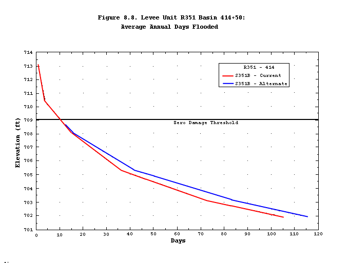
Given the diminishing differences between the exterior stage duration curves and the interior number of days flooded curves for more downstream levee units, it can be deduced that difference between the interior number of days flooded diminishes downstream for the two plans. Figures 8-6, 8-7, 8-8, 8-9 and 8-10 show the interior number of days flooded curve for the basin with the lowest levee unit outlet relative to the river for each of the levee units from L536 downstream to Tri-County LD 2. The more downstream basins, regardless of their outlet elevations, show little or no difference in interior ponding between plans for both spring and non-spring seasons.
The relative and absolute level of potential impact of differing releases from Gavins Point Dam on interior ponding are shown in Table 8.2. The average June interior areas for the Alternative Plan were greater than those of the CWCP except for Basin L246 B. There are no basins downstream of L536 where the difference in the average June interior area was greater than 10 acres. This demonstrates the diminishing relative downstream differences in interior pond area between plans.
| Levee Unit | Basin | Average June | Difference June | Plan | Zero-Damage Thres. | June Differences1 | ||||
| Interior Area (acres) | Ap-CWCP (acres) | maximum Elev (fmsl) | Elev (fmsl) | Area (acres) | CWCP-ZT (acres) | Ap-ZT (acres) | ||||
| AP | CWCP | |||||||||
| L575 | E | 156.72 | 62.06 | 94.66 | 922.78 | ap | 916.10 | 34.87 | 27.19 | 121.85 |
| F | 329.46 | 184.92 | 144.54 | 920.67 | ap | 916.00 | 335.40 | -150.48 | -5.94 | |
| G | 43.57 | 25.15 | 18.42 | 919.54 | ap | 913.20 | 3.16 | 21.99 | 40.41 | |
| H | 117.32 | 53.35 | 63.97 | 912.12 | ap | 909.00 | 97.50 | -44.15 | 19.82 | |
| J | 39.54 | 9.75 | 29.79 | 902.66 | ap | 898.60 | 10.17 | -0.42 | 29.37 | |
| L | 4.82 | 4.09 | 0.73 | 898.76 | cwcp | 897.20 | 50.10 | -46.01 | -45.28 | |
| L5362 | A | 67.56 | 51.34 | 16.22 | 874.58 | ap | 870.00 | 82.80 | -31.46 | -15.24 |
| B | 17.08 | 13.18 | 3.90 | 879.76 | cwcp | 879.00 | 185.01 | -171.83 | -167.93 | |
| C | 25.57 | 15.67 | 9.90 | 881.71 | ap | 878.00 | 54.40 | -38.73 | -28.83 | |
| D | 51.31 | 36.87 | 14.44 | 881.81 | ap | 878.00 | 40.40 | -3.53 | 10.91 | |
| E | 4.04 | 3.46 | 0.58 | 883.19 | ap | 880.00 | 13.90 | -10.44 | -9.86 | |
| L497/488 | 497-L2 | 51.93 | 43.89 | 8.04 | 837.76 | ap | 835.00 | 194.00 | -150.11 | -142.07 |
| W | 15.35 | 13.65 | 1.70 | 832.00 | - | 826.50 | 17.75 | -4.10 | -2.40 | |
| E | 0.98 | 0.68 | 0.30 | 832.22 | ap | 830.20 | 27.00 | -26.32 | -26.02 | |
| E2 | 14.56 | 11.57 | 2.99 | 828.27 | cwcp | 824.50 | 41.30 | -29.73 | -26.74 | |
| E4 | 1.40 | 1.39 | 0.01 | 826.14 | ap | 822.39 | 21.11 | -19.72 | -19.71 | |
| R351 | 79+70 | 0.09 | 0.08 | 0.01 | 721.93 | cwcp | 719.00 | 7.90 | -7.82 | -7.81 |
| 414+50 | 12.32 | 9.88 | 2.44 | 712.10 | cwcp | 709.00 | 26.40 | -16.52 | -14.08 | |
| 445+50 | 0.03 | 0.03 | 0.00 | 712.08 | ap | 708.00 | 2.30 | -2.27 | -2.27 | |
| 526+20 | 0.05 | 0.02 | 0.03 | 711.70 | ap | 708.50 | 6.20 | -6.18 | -6.15 | |
| 591+80 | 0.03 | 0.03 | 0.00 | 713.19 | cwcp | 710.00 | 11.00 | -10.97 | -10.97 | |
| 618+70 | 0.02 | 0.02 | 0.00 | 713.80 | cwcp | 712.00 | 1.60 | -1.58 | -1.58 | |
| 632+32 | 0.16 | 0.16 | 0.00 | 715.50 | ap | 715.50 | 2.40 | -2.24 | -2.24 | |
| L246 | A | 11.07 | 10.27 | 0.80 | 622.06 | cwcp | 620.00 | 45.00 | -34.73 | -33.93 |
| B | 10.47 | 10.57 | -0.10 | 627.82 | ap | 622.00 | 13.30 | -2.73 | -2.83 | |
| C | 73.00 | 73.50 | -0.50 | 622.09 | ap | 618.00 | 150.00 | -76.50 | -77.00 | |
| D | 25.51 | 22.13 | 3.38 | 623.20 | ap | 620.00 | 155.00 | -132.87 | -129.49 | |
| E | 58.80 | 56.80 | 2.00 | 634.20 | ap | 634.00 | 160.00 | -103.20 | -101.20 | |
| F | 0.35 | 0.35 | 0.00 | 629.08 | ap | 630.00 | 195.00 | -194.65 | -194.65 | |
| H | 14.50 | 12.81 | 1.69 | 629.57 | cwcp | 622.00 | 80.00 | -67.19 | -65.50 | |
| I | 1.32 | 1.31 | 0.01 | 627.98 | ap | 628.00 | 15.00 | -13.69 | -13.68 | |
| Tri-County LD2 | 1 | 1.91 | 1.83 | 0.08 | 503.09 | cwcp | 501.50 | 9.53 | -7.70 | -7.62 |
| 2 | 10.58 | 10.49 | 0.09 | 502.58 | cwcp | 498.00 | 10.40 | 0.09 | 0.18 | |
| 3 | 0.00 | 0.00 | 0.00 | 500.13 | - | 498.00 | 0.10 | -0.10 | -0.10 | |
| 4/5 | 43.97 | 42.44 | 1.53 | 496.97 | ap | 495.00 | 120.00 | -77.56 | -76.03 | |
| 6 | 0.67 | 0.65 | 0.02 | 501.92 | - | 499.00 | 2.50 | -1.85 | -1.83 | |
| 7 | 3.15 | 2.86 | 0.29 | 499.65 | - | 495.30 | 25.00 | -22.14 | -21.85 | |
| 8 | 31.13 | 30.98 | 0.15 | 499.15 | cwcp | 494.00 | 29.00 | 1.98 | 2.13 | |
| Avg. = | -38.38 | |||||||||
| Std. = | 55.43 | |||||||||
| AVG+STD/2= | -10.66 | |||||||||
| 1Bold values indicate ponds with average June pond areas with greater than the average plus one-half a standard deviation of all exceedances of the zero-damage threshold area. NOTES: AP=Alternative Plan; CWCP=Current Water Control Plan; ZT=Zero-Damage Threshold |
||||||||||
| 2L536 results are based on unrevised sets of exterior stages (see Section 3.6) | ||||||||||
Zero-damage threshold areas and corresponding elevations are shown in Table 8-2 for comparison of the river stages of both plans in an absolute, rather than in a relative, manner. The table shows the difference between the Alternative Plan pond areas and the zero threshold ponding area, and the CWCP pond areas and the zero threshold ponding area. The overwhelming majority of the differences are negative, which shows that the ponding is typically below the damage threshold. Only two ponds in L575 and two in Tri-County show potential damages based on CWCP average June ponding, with the maximum exceedance of the damage threshold being less than 30 acres. The Alternative Plan has three more ponds with potential damages than the CWCP: two more in L575 and one in L536. The maximum Alternative Plan exceedance of the damage threshold is about 120 acres. For both plans, pond E of Levee Unit L575 had the maximum exceedance of the damage threshold. The bold values shown in Table 8-2 identify the ponds that are more a risk of crop damages due to interior flooding. An arbitrary criterion of -10.66 acres (based on the average plus one-half of the standard deviation of the values in the CWCP-ZT column) was used to select the higher risk ponds. There are 17 ponds in the higher risk category for the CWCP plan and 18 ponds for the Alternative Plan.
These conclusions regarding river mile, outlet elevation, and the number of days with interior ponding are important factors to consider when comparing plan costs and benefits. The validity of these conclusions is based on the models' accuracy of calibration, validation, and evaluation of their sensitivity to key parameters. The short-term spring season analysis of the simulations further supports the validity of the model by its ability to demonstrate hydrologic and drainage processes that are expected to occur.
It is important to remember the purpose of the modeling conducted in support of the Master Manual Study. The purpose was not to develop a predictive tool, capable of making interior flooding estimates in real time, but rather to allow the Corps to quantify the relative impacts of alternative system operations with respect to the CWCP. There are many variables and uncertainties that HEC-IFH does not capture in simulation, such as the failure of non-Federal levees or flows breaking ditches during such failures. Similarly, the loss of a pump or the decision to shut a pump down after a major event that wipes out the potential for crop recovery within the current season (such as might have occurred at many locations during the 1993 floods) cannot be easily simulated by HEC-IFH. However, the model does provide a useful tool for quantifying incremental effects over a long period of simulation. Although the absolute accuracy of results during any given year is not guaranteed, the expectation is that, over the 45-year simulation period, the relative impacts are reasonably quantifiable and serve the NEPA process in evaluating alternative operating plans for the Master Manual.